BrightEarth On Premises
Your geospatial production platform, deployed securely within your infrastructure.
Take full control of your geospatial data production with BrightEarth On Premises – LuxCarta’s in-house solution for generating 3D buildings, land cover, and more, all within your private environment.
Why BrightEarth On Premises?
BrightEarth On Premises delivers LuxCarta’s AI-powered mapping technology directly to your infrastructure, giving you unmatched control, security, and scalability. Generate high-resolution geospatial data – from 3D buildings to land use/land cover (LULC) – while keeping all sensitive data in-house.
-
-
-
Full Data Sovereignty – process and store data entirely within your secured infrastructure.
-
Enterprise-Grade Production – generate the same high-quality outputs as BrightEarth cloud, at scale.
-
Customizable & Scalable – adapt workflows to meet your project and compliance needs.
-
-


Key Features
|
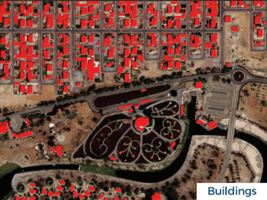
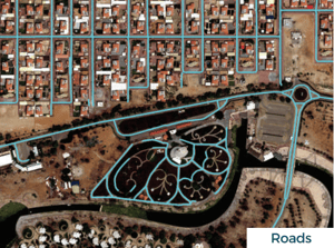
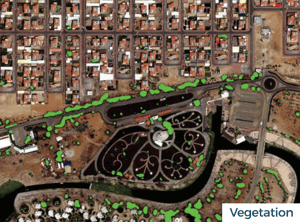
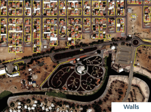
AI-Driven Feature Detection Automatically detect and vectorize key landscape features - such as buildings,roads, trees, and walls - with exceptional accuracy. Achieve over 90% precision using cutting-edge AI algorithms trained on high-resolution satellite imagery (30cm and 50cm) |
Comprehensive Landscape Analysis Extract detailed semantic attributes, including building heights, roof shapes and colors, as well as tree heights and colors. Generate High-quality 3D geospatial outputs to seamlessly integrate into your applications |
|
Customizable Models Fine-tune detection models to align with your specific imagery and ground truth data, ensuring improved accuracy and adaptability for similar environments |
Scalable & Secure Onsite Deployment Deploy effortlessly within your internal infrastructure, maintaining complete control over data privacy, security and licensing - all within your secure network |
BrightEarth On Premises comes with powerful add-on capabilities, including
SimpliCity and SuperRes.
SimpliCity
Automated 3D Building Modeling
Generate clean, lightweight 3D building models directly from LiDAR data with Simplicity. Our automated workflow removes noise, regularizes geometry, and delivers watertight outputs ready for GIS, CAD, or simulation tools.
SuperRes
Sharper Satellite Imagery
Enhance satellite imagery by a factor of 4 with SuperRes. Turn medium-resolution inputs into clear, detailed visuals for smarter analysis, mapping, and urban planning, at a fraction of traditional processing costs.
BrightEarth On Premises
Bring AI-powered 3D geospatial data to your infrastructure
Bring AI-powered 3D geospatial data to your infrastructure
BrightEarth On Premises is an AI-powered software suite installed on your own infrastructure, enabling secure, offline generation of actionable 3D geospatial data. Designed for sensitive environments and high-performance needs, it delivers precise building, road, and land-use layers directly from satellite imagery. Run it on a single machine or scale across servers — ideal for defense, mapping, and simulation industries.
